

Accurate, Intelligent, and Efficient 3D Reconstruction Software

DJI Terra
Make the World Your Digital Asset

Cart
Your cart is empty
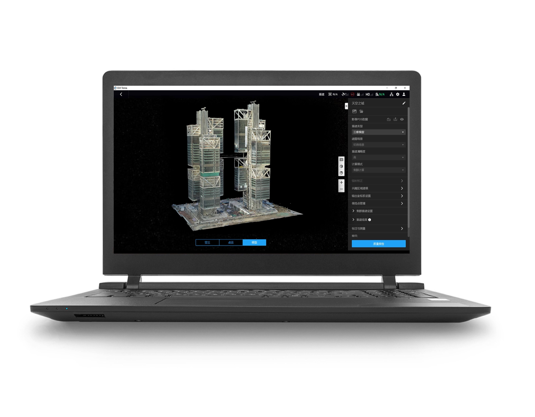
DJI Terra is 3D modeling software equipped with next-generation reconstruction technologies[1], including 3D Gaussian Splatting. It supports accurate and efficient 2D and 3D reconstruction from visible light imagery, and processes data collected by DJI LiDAR.
When integrated with DJI drones and DJI Modify [2], Terra delivers a unified hardware and software solution for data acquisition, processing, and application, streamlining aerial surveying workflows for greater efficiency and accuracy.
[1] System requirements: Windows 10 or above (64-bit), 32 GB of RAM, and an NVIDIA graphics card with at least 4 GB of GPU memory and compute capability 6.1 or above.
[2] DJI Modify, DJI's first intelligent 3D model editing software, can work with DJI Terra to provide a comprehensive solution for aerial surveying, modeling, model editing, and sharing. To learn more about DJI Modify, click Learn about DJI Modify .
[3] Multispectral reconstruction supports DJI Mavic 3 Multispectral and Phantom 4 Multispectral.
[4] Only online licenses are available in DJI Store. Please ensure network connectivity when you use the software. Each license can be bound to only one DJI account and one computer, and the account that is bound to a license cannot be changed. If you want to purchase other licenses, such as an offline license or an Education license, click Learn about DJI Terra for more information, or click Contact Us to start a purchase inquiry. For more information, see FAQ .

Make the World Your Digital Asset
DJI Terra is 3D modeling software equipped with next-generation reconstruction technologies, including 3D Gaussian Splatting. It supports accurate and efficient 2D and 3D reconstruction from visible light imagery, and processes data collected by DJI LiDAR. When integrated with DJI drones, Terra delivers a unified hardware and software solution for data acquisition, processing, and application, streamlining aerial surveying workflows for greater efficiency and accuracy.
Terra introduces Gaussian Splatting, which quickly generates detailed and realistic 3D models from photos, accurately restoring diverse scenes such as cultural relics, architectural projects, urban blocks, and scenic gardens. Compared to visible-light oblique photogrammetry technology, 3D Gaussian Splatting significantly enhances the representation of complex elements like fine structures, transparent and reflective objects, and vegetation. In addition to producing more natural rendering effects, this technology can also generate distortion-free orthomosaics, further improving the quality of the results.
Terra processes approximately 500 photos per hour [2], allowing a single-block modeling process [3] to be completed in just 30-40 minutes [2]. In large scenes with over 10,000 photos, the reconstruction speed is twice that of Terra Mesh [1], leading the industry. The strong processing capability helps users obtain high-quality 3D data more quickly, significantly shortening project timelines and enabling rapid modeling and application in large-scale scenes.
With efficient resource utilization, Terra supports city-scale scene reconstruction using Gaussian Splatting. Approximately 300-400 photos can be processed per 1 GB of available RAM [4], and a single processing task can handle up to 30,000 photos [4]. This capability fully meets the 3D modeling needs of large-scale, complex environments such as urban spaces, industrial parks, and infrastructure, providing a solid data foundation for urban digitalization and smart city management.
Terra supports one-click export to mainstream 3D Gaussian Splatting data formats such as PLY and B3DM (3D Tiles). The results can be seamlessly integrated into third-party platforms across industries, including surveying and mapping, gaming, and film production. Standardized data outputs facilitate efficient data reuse and sharing across multiple fields and platforms, allowing users to expand flexibly into diverse application scenarios.
Terra achieves centimeter-level mapping accuracy without the need for ground control points by deeply integrating data collected by DJI mapping drones (equipped with RTK modules) with intelligent algorithms. It supports the output of various results, including 3D mesh models, point clouds, and 2D maps. For DJI Enterprise mapping drones like Matrice 4E, Terra offers dedicated accuracy enhancements. Even in complex environments, Terra consistently meets 1:500 mapping standards, supporting the demanding requirements of engineering surveys, topographic mapping, and more.
Leveraging advanced positioning technologies such as RTK and PPK, Terra processes point cloud data from the Zenmuse LiDAR to achieve survey-grade, centimeter-level accuracy without the need for ground control points. This ensures reliable data support for high-standard mapping and engineering monitoring applications.
Terra efficiently processes large-scale LiDAR point cloud data, handling approximately 1 GB of point cloud data per 1 GB of available RAM. This enables seamless management of extensive projects. A computer with 32 GB of RAM can process up to 120 GB of data [5], covering an area of approximately 10 square kilometers [9]. For city-scale data processing, workstations with 128 GB of RAM is supported [5][10]. [11]
Terra enables the creation of accurate prescription maps using multispectral or visible light data. Simply select your crop type (Field or Fruit Tree) to quickly generate 2D maps and optimized route plans for DJI Agras drones. Terra also supports the generation of variable-rate spraying prescription maps, which can be used with DJI's Agras drones to improve crop yields while reducing costs.
With one-click activation, Terra enables direct handoff to DJI Modify for instant generation of model processing files and post-editing. As DJI's first intelligent 3D mesh and point cloud editing software, Modify offers features such as point cloud smoothing, noise reduction, downsampling, and classification. It also generates terrain results that can be easily imported into industry-standard software such as GIS and CAD. Paired with DJI Enterprise drones and DJI Terra, this forms a comprehensive solution from aerial surveying and modeling to model editing and sharing, meeting the needs of surveying and mapping, firefighting, emergency response, and transportation.

Surveying and Mapping
Electricity
Oil and Natural Gas

Promotions, new products and sales. Directly to your inbox.
